BC STORIES
Dangerous Winter Storm Conditions Persist: Heavy Snow and High Winds Forecast for Coquihalla Highway
Travelers are warned of hazardous winter conditions on the Coquihalla Highway between Hope and Merritt as Environment Canada forecasts continued heavy snowfall and high winds throughout the weekend.


Winter Storm Continues to Impact Interior British Columbia
Motorists planning to traverse the British Columbia interior are being urged to exercise extreme caution as a relentless winter storm continues to blanket the Coquihalla Highway (Highway 5) with significant snowfall. Environment Canada has maintained a travel advisory for the stretch of highway between Hope and Merritt, citing hazardous conditions that are expected to persist throughout the weekend. With visibility frequently reduced to near zero and road surfaces becoming increasingly treacherous, provincial authorities are advising against non-essential travel until the system subsides.
According to the latest meteorological reports, an additional 10 to 20 centimeters of snow is forecast to accumulate by Sunday evening. This snowfall is being driven by a stationary Pacific frontal system that has pinned itself against the Cascade Mountains, dumping moisture onto the high-elevation passes. The Coquihalla Summit, which sits at an elevation of 1,244 meters, is bearing the brunt of the storm. Meteorologists warn that while the valley bottoms may see a mix of rain and snow, the mountain passes will experience heavy, consistent white-out conditions.
High Winds and Drifting Snow Create Visibility Hazards
It is not merely the volume of snow that is causing concern for the Ministry of Transportation and Infrastructure, but the accompanying high winds. Forecasts indicate sustained wind speeds of 40 to 60 kilometers per hour, with gusts reaching up to 80 kilometers per hour in exposed areas near the Great Bear Snowshed. These winds are causing significant blowing and drifting snow, making it nearly impossible for snowplows to maintain clear lanes for extended periods. When combined with the heavy snowfall, these conditions create white-out scenarios where drivers can lose sight of the road markings and the vehicles ahead of them.
DriveBC, the provincial traffic information service, has reported multiple minor incidents involving spun-out vehicles and semi-trucks over the last 24 hours. While no major injuries have been reported, the cumulative effect of these incidents has led to intermittent delays and temporary lane closures. The Coq is a challenging route even in fair weather, noted one highway patrol officer. When you add 20 centimeters of fresh powder and 80-kilometer winds, it becomes an environment where even the most experienced drivers can find themselves in trouble.
Safety Protocols and Winter Tire Requirements
Under British Columbia law, winter tires or chains are mandatory for all vehicles traveling on the Coquihalla Highway during this season. Conservation officers and the RCMP are conducting periodic checks to ensure compliance. Passenger vehicles must have tires with the mountain-snowflake or M+S symbol and at least 3.5mm of tread depth. Commercial vehicles over 11,794 kg must carry chains and be prepared to install them at designated pull-outs. Failure to comply not only results in significant fines but also puts other road users at risk during these severe weather events.
Maintenance contractors for the highway have deployed their full fleet of plows, graders, and salt trucks. However, the intensity of the snowfall often means that by the time a plow completes its circuit, several new centimeters of snow have already accumulated on the tarmac. Drivers are reminded to never pass a snowplow on the right and to maintain a safe following distance of at least 30 meters to allow operators to work effectively. We are doing everything we can to keep the artery open, a spokesperson for the maintenance contractor stated, but the sheer volume of snow requires us to prioritize safety over speed.
Emergency Preparedness for High-Elevation Travel
For those who must travel, emergency management officials recommend carrying a winter survival kit. This kit should include blankets, extra clothing, non-perishable food, water, a first-aid kit, and a small shovel. Keeping a full tank of gas is also critical, as idling for warmth during a road closure can quickly deplete fuel reserves. Furthermore, travelers should ensure their mobile devices are fully charged and that they have shared their travel plans with a friend or family member. In the high-elevation stretches of the Coquihalla, cell service can be spotty, making it difficult to call for help if a vehicle leaves the roadway.
The geography of the Coquihalla makes it uniquely susceptible to rapid weather shifts. Known as a high-mountain pass route, the highway climbs steeply from sea level at Hope into the rugged terrain of the interior plateau. This rapid ascent often transitions mild rain into freezing rain or heavy snow within minutes. Historical data shows that the Coquihalla is one of the most unpredictable highways in North America during the winter months, often seeing more snow in a single weekend than many cities see in an entire year.
Looking Ahead: Forecast for the Work Week
While the immediate focus remains on the weekend snowfall, long-range forecasts suggest that the weather pattern may begin to shift by late Monday. A colder air mass from the north is expected to move in, which should taper off the heavy precipitation but will bring significantly lower temperatures. While the snow may stop falling, the risk of black ice will increase as the moisture on the roads freezes solid. Travelers are encouraged to check DriveBC frequently for the most up-to-date information on road conditions and closures before embarking on their journey.
In summary, the Coquihalla Highway remains a high-risk zone for the next 48 hours. The combination of heavy snow, high winds, and high traffic volume creates a volatile situation. The provincial government and Environment Canada continue to monitor the situation closely, and further advisories may be issued if the storm intensifies. For now, the message to the public remains clear: if you do not need to be on the Coquihalla this weekend, stay home and avoid the risks associated with this severe winter weather event.

BC STORIES
BC Supreme Court Judge Set to Rule on Sentence Length for Former Gang Member
Defence lawyers recommend 12 to 14 years for Ekene Anigbo for the 2021 Naramata manslaughter of Kathleen Richardson. A judge rules Nov. 2 in Kelowna.


Judicial Decision Expected in November
B.C. Supreme Court Justice Alison Beames is scheduled to deliver a sentencing ruling on Nov. 2 regarding Ekene Anigbo following a two-day hearing in Kelowna.
Defence lawyers for the 27-year-old former gang member have asked the court for a term of 12 to 14 years. Anigbo was convicted of manslaughter on Aug. 14 in connection with the June 9, 2021 death of 57-year-old Kathleen Richardson inside her Naramata residence.
Dispute Over Rehabilitation and Penalty
The recommendation from the defence directly contrasts with the prosecution’s request on Oct. 7 for life imprisonment without parole eligibility for 10 years. Defence counsel argued that the Crown was seeking to artificially inflate the sentence, pointing out that Anigbo has ended his gang ties since 2024 and completed anger management, employability skills, and Indigenous programming at Okanagan Correctional Centre.
If Justice Beames adopts the defence proposal, Anigbo would become eligible to apply for parole after completing one-third of the sentence.
Details of the Fatal Incident
Anigbo was originally tried for first-degree murder, but Justice Beames determined the Crown did not prove beyond a reasonable doubt that he fired the lethal shots. However, court proceedings established that Anigbo and co-accused Jalen Falk entered the home together armed with at least two handguns to track down Richardson’s son, Wade Cudmore, who was believed by associates to have killed two brothers and stolen cash and drugs.
When they discovered Cudmore was absent, the pair attempted to extract information from Richardson. Evidence showed she resisted, sustaining non-fatal injuries to her hands and arms, before the two men worked together to kill her and fled the scene. Her body was later discovered in her basement by an RCMP officer arriving to caution Cudmore about potential danger.
Related Legal Outcomes
The fatal event was tied to a broader sequence of violent incidents. Cudmore was taken into custody the day after his mother’s body was found and was subsequently convicted of two counts of second-degree murder involving the deaths of brothers Erick and Carlos Fryer.
Meanwhile, Falk entered a guilty plea to second-degree murder for Richardson’s death and received a life sentence in February with no chance of parole for 16 years.
BC STORIES
Loss of Newborn Calf Puts Fresh Focus on Endangered Southern Resident Whales
A critically endangered southern resident killer whale, J31, was seen pushing a dead newborn calf in B.C. waters, raising concerns for the population.
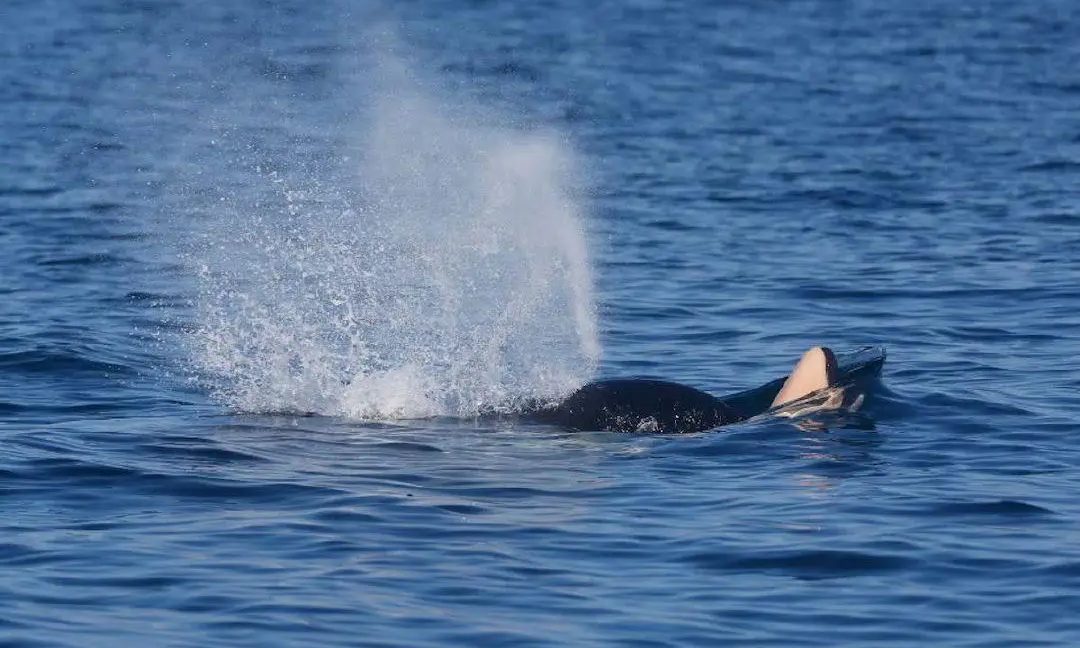
Tragic Sight Recorded Off Sombrio Point
Researchers with the Center for Whale Research confirmed that a female southern resident killer whale was seen pushing a dead newborn calf on her nose on Oct. 3 in the Strait of Juan de Fuca near Sombrio Point.
Mark Malleson, a researcher with the Washington-based organization, spotted the 31-year-old orca—identified as J31 or Tsuchi—travelling alongside her immediate family. According to a statement from the group, “It s unclear whether the newborn was a male or female, if it had been carried to full term prior to birth, and if it died after birth or was a stillbirth.”
Reproductive History and Population Pressures
Born in 1995, Tsuchi has a history of reproductive loss, including failed pregnancies and a deceased calf she carried in 2016. Her only surviving offspring is J56, a female named Tofino who was born in 2019.
The loss underscores the deep reproductive challenges confronting the critically endangered population. The Center for Whale Research emphasized that access to large, nutritionally rich Chinook salmon remains one of the primary factors limiting their ability to recover.
“For a population as small as the southern residents, the successful birth and survival of every calf matters,” the organization stated.
Pattern of Loss Across Pods
Tsuchi’s loss recalls similar events documented in the southern resident population, which comprises J, K and L pods. In 2018, J35 (Tahlequah) gained international attention after carrying her dead calf over 1,600 kilometres during a 17-day journey. Tahlequah was seen carrying another dead calf on her head or snout in early 2025. Later that year, 26-year-old J36 (Alki) lost a female calf—marking her fifth documented pregnancy, with only one calf surviving past infancy for under two years.
Recent census data from the Center for Whale Research recorded 74 southern residents, up by one from 73 in 2024. Although two births—K47 in December of last year and L130 in June—raised the total to 76, another calf, L129, is presumed dead after going missing from L-pod in June following observations of poor physical condition.
“The southern resident killer whales remain critically endangered, and their recovery depends not simply on increasing the number of pregnancies, but on creating the conditions in which mothers and calves can survive and thrive,” said the Center for Whale Research.
BC STORIES
Defense Seeks 12 to 14 Years as Judge Weighs Sentence in Naramata Manslaughter Case
Defense lawyers recommend 12 to 14 years for Ekene Anigbo following his manslaughter conviction in the 2021 death of Kathleen Richardson in Naramata.

Competing Sentence Recommendations Presented in B.C. Supreme Court
Defense lawyers representing former gang member Ekene Anigbo have asked a court for a prison sentence ranging from 12 to 14 years, arguing that the 27-year-old is making progress toward rehabilitation. Anigbo appeared in B.C. Supreme Court in Kelowna on Oct. 8 for the second day of his sentencing hearing following his Aug. 14 conviction for manslaughter in the death of 57-year-old Kathleen Richardson.
The defense’s proposal stands in contrast to the position of the Crown, which asked on Oct. 7 for a life sentence with no chance of parole for 10 years. Anigbo’s legal team criticized the prosecution’s request, contending that it was an attempt to “artificially inflate” the penalty. If the judge accepts the defense recommendation, Anigbo would become eligible to apply for parole after completing one-third of his term.
Details Surrounding the 2021 Naramata Homicide
The conviction stems from an incident in the early hours of June 9, 2021, when Anigbo and co-accused Jalen Falk entered Richardson’s home in Naramata searching for her son, Wade Cudmore. While Justice Alison Beames ruled that the prosecution did not prove beyond a reasonable doubt that Anigbo fired the fatal shots, the court determined the two men worked together and killed Richardson, whose body was discovered in her basement later that day.
Court proceedings revealed that the intrusion was linked to a broader conspiracy rooted in the killing of brothers Erick and Carlos Fryer. Anigbo’s associates suspected Cudmore was involved in the brothers’ deaths and had taken drugs and money. Armed with at least two firearms, Anigbo and Falk sought information on Cudmore’s whereabouts from Richardson. Evidence showed Richardson resisted, sustaining non-fatal injuries to her hands and arms before being killed.
Subsequent Legal Outcomes and Upcoming Ruling
An RCMP officer found Richardson’s body while visiting the residence to alert Cudmore that his safety might be at risk. Cudmore was taken into custody the following day for the deaths of the Fryer brothers and was subsequently convicted on two counts of second-degree murder. In February, Falk admitted guilt to second-degree murder in connection with Richardson’s death, receiving a life sentence with parole eligibility set at 16 years.
During his time held at the Okanagan Correctional Centre, Anigbo has taken courses in employability skills, anger management, and Indigenous programs, with court hearing he has maintained no gang ties since 2024. Justice Beames is scheduled to deliver the court’s sentencing decision on Nov. 2.

Where Provincial Jobless Rates Stood in September
What New Brunswick’s Latest Unemployment Figures Mean for Your Community

Who Is Running in Your Riding for the 2026 BC Election?

How Central Okanagan Residents Can Avoid Costly Household Plumbing Damage This Thanksgiving

BC Supreme Court Judge Set to Rule on Sentence Length for Former Gang Member

Loss of Newborn Calf Puts Fresh Focus on Endangered Southern Resident Whales

Opinion: John Rustad Has to Go

B.C. Supreme Court Grants Cowichan Tribes Title to Historic Richmond Lands and Fishing Rights

Vancouver Canucks Gear Up for a Make-or-Break 2025–26 Season

Province to Appeal Cowichan Tribes Land Decision

Kamloops Prepares Four Reverse Referendums on $188M in Major Projects

Kamloops Blazers Announce Off-Season Changes Ahead of 2025–26 Season
-

 LOCAL7 days ago
Have You Seen Him? Public Help Sought in Locating Missing Traveller Last Seen in Kamloops
-

 BC STORIES7 days ago
Why a Familiar Political Name is Joining the Kamloops-North Thompson Race
-
LOCAL6 days ago
Your Current 3 Day Forecast — October 4, 2026
-

 LOCAL6 days ago
Two Displaced as Investigators Eye Suspicious Four-Plex Fire in Kelowna
-

 COMMUNITY4 days ago
Why Okanagan Pet Owners Turned to Free BC SPCA Clinics After Wildfire Season
-

 OPINIONS3 days ago
B.C. Election Poll Puts Conservatives Ahead Five Points as Cost of Living Tops Voters’ Concerns
-

 BC STORIES3 days ago
B.C. Patients Could Soon Select Surgical Lists Based on Wait Times Under NDP Plan
-
LOCAL3 days ago
Your Current 3 Day Forecast — October 7, 2026